Biodiversity and Ecosystem Services Trends and Conditions Assessment Tool
BESTCAT
Executive Summary
Corporate sustainability managers must measure, manage, and report critical biodiversity and ecosystem services impacts and dependencies. Investors, regulators, and lenders increasingly require companies to accurately assess and proactively address global environmental risk. With BestCat, The Nature Conservancy provides companies with an effective tool for managing biodiversity sensitivity and regulatory compliance that helps transparently communicate potential risks to stakeholders. for companies with global biodiversity footprints and promotes efficient and cost effective approach to risk management. For more information regarding the current metrics used in BestCat, see the help documentation.
Description
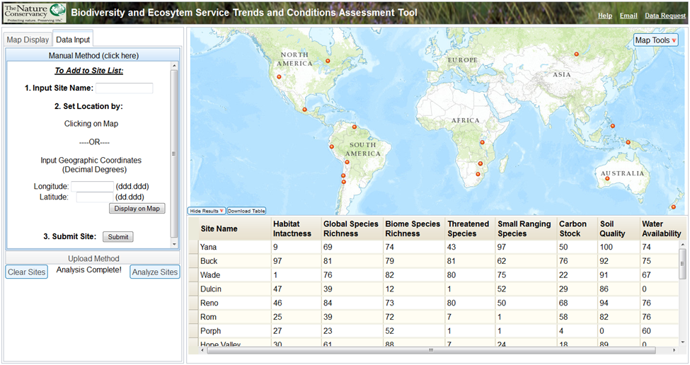
BestCat is a web-based mapping application which provides companies with the ability to compare and contrast global assets based on value and condition of ecosystems and associated biodiversity. This easy-to-use and efficient application provides businesses with a preset data package that highlights biodiversity and ecosystem service risk and quickly identifies critical locations that require risk management. BestCat analysis provides a basis for developing cost effective risk mitigation approaches by identifying areas that are associated with potential environmental liabilities. Currently, the application focuses primarily on biodiversity with the ultimate goal of incorporating additional aspects of ecosystem services into the analysis. BestCat was developed by The Nature Conservancy in partnership with Dow Chemical as a free, open source application based on peer-reviewed science, see Oakleaf et al., 2013.
Application
BESTCAT has two main components; the map resources panel (left section) and the map display (right section). The map resources panel gives users the ability to modify the displayed information within the Map Display tab. The map display presents the spatial data associated with the application. A set of map tools gives users the ability to interact with the map display by setting the view extent of the map, obtain attribute information for any of the displayed data, add their own spatial data to the map, and/or print the displayed map. The Data Input tab gives users the ability to upload and/or create sites to analyze with regards to the biodiversity and ecosystem services metrics.
